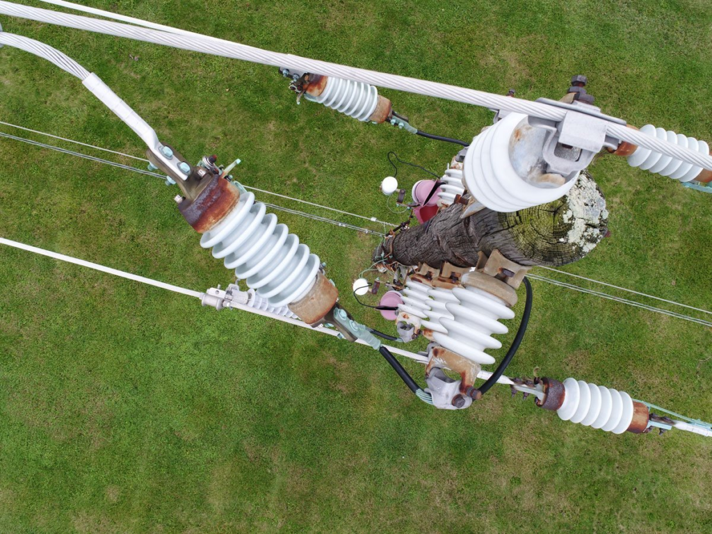
Today’s energy and utilities organizations are using drones to capture data that was previously too dangerous, difficult or expensive to obtain. While the full potential of drone technology is still being realized, it’s clear that drones are a must-have for energy companies looking to reduce costs, increase safety and revolutionize their workflows.
In this article, we’ll highlight some of the top use cases and benefits of drones as they relate to the transmission & distribution, wind and solar—and show how Measure Ground Control makes it easier. Let’s dive right in!
Transmission power spot checks
Drone technology can drastically reduce asset inspection time and save labor costs, while providing higher-quality data that enables companies to maximize energy production.
Using drone imagery, personnel can measure the health of entire operations to quickly pinpoint problems and develop rapid solutions. This is especially true for the most hazardous asset inspections, such as transmission towers and substations.

Imagine getting a call about a transmission tower in an area that’s inaccessible by a lineman. Traditionally, a transmission tower inspection would take dozens of hazardous worker hours to complete. With a drone, you can quickly access the tower, gather real-time imagery, and come up with a diagnosis within minutes.
Arnold understands the importance of routine inspections, timely maintenance and compliance. Measure Ground Control gives you access to information about your inspections—flight logs, screenshots, playbacks and incident flagging.
Storm restoration
Drones reduce the time it takes to investigate damage from storm-related power outages. Equipped with proper software and trained drone pilots, energy companies can observe entire paths of storm destruction and come up with a recovery plan.
The aftermath of violent storms can leave a trail of destruction that limits road access. This is especially true after a natural disaster—the terrain conditions may be unknown and using drones can help assess damaged power generators.
You can create a cohesive visual overview with Measure Ground Control. Upload ground control points, image layers or 2D data files to study areas in greater detail.
Site & vegetation surveying
High-resolution aerial inspections allow energy companies to study growth that might interfere with nearby solar panels. Multispectral sensors can show you which vegetation is actively growing and needs to be cleared and which vegetation is dormant and isn’t going to encroach on your sites. That way, your team can focus on clearing brush that is an active problem while ignoring dead growth that isn’t.
Measure Ground Control makes progress reporting easy. Using cloud-based data, your team can plan flights, record data and review information to get a valuable perspective on sites whenever you need it.
Tracking wind turbine degradation
We’d previously mentioned how major asset inspections, like those of transmission towers or substations, are expensive and time-consuming endeavors. As a result, energy companies often aren’t able to conduct those inspections as often as they’d like. Sometimes, they’re only able to inspect these high-value assets annually.
Since drones make it easier and more efficient to conduct these types of inspections, assets can be reviewed more frequently, such as quarterly inspections of wind turbines. More regular inspections enable energy companies to better track the natural degradation of their assets to see how they perform and hold up over time.
Measure’s secure online portal and customized reporting tools enable our users to easily track performance of assets over time, even comparing and contrasting different manufacturers.
Commissioning and asset transfers
Asset purchasers, financiers or energy off-takers have a limited amount of time to assess and accept a new solar or wind farm. Drones offer a quick way to capture data samples that stakeholders can use to measure the sustainability of entire wind and solar farms.
Commissioning with drones is more efficient than manual inspections and identifies defects, tracker misalignment, shading, tower and substation conditions that manual inspections might miss.
With Measure’s API integration capabilities, energy companies can disseminate information into data lakes immediately and automatically. No more manual logs and uploads required.
Corridor mapping
Drones offer real-time visibility of areas that stretch for miles, such as oil pipelines or miles of transmission towers. Corridor mapping via drones is more efficient, requires less manpower and yields better results than traditional surveying methods.
Traditionally, energy companies invest a lot of time and resources to gather data on these large survey operations. A manual survey of a large area may require workers to face hazardous conditions—extreme temperatures, wildlife and dehydration. Helicopters are a common alternative, but are expensive and unable to capture aerial imagery at the proper angle and are disruptive to wildlife and local residents.
Drones provide a safe way to get a detailed view of terrain in the shortest amount of time. You can create automated flights to capture the exact paths you want, or you can manually fly your drones to build your maps. You can also equip drones with a variety of sensors that can give you detailed information on topography, vegetation and more.
Measure makes it easy to build detailed maps from your drone data. Start your free trial today and build two free maps a month.
Volumetrics
Informed decision-making begins with accurate data. Drones are the preferred solution for measuring assets because they give energy companies an accurate snapshot of stockpiles and sites in minutes.
Drones use images captured from dense grid pattern aerial photography to produce a point cloud and a digital surface model to estimate volume. This process is faster than traditional methods and requires fewer resources.
Measure Ground Control puts intelligent inspection modes and data analysis tools at your fingertips, allowing your company to better plans for the future.
How else can Measure Ground Control help?
Measure Ground Control remains the leader in aerial intelligence solutions. Our team has 30 years of combined experience in drone software and operations. We’re here to help with custom setup and onboarding processes and priority customer support to ensure that Measure works best for you.


