Field scouting is an important part of managing an orchard and doing so effectively takes up a considerable amount of time. “Growers like my Dad are on the tractor almost daily. He works every part of the field and has a pulse on every acre,” Chris explains. “My involvement in his operation is pretty limited. I work full time for another grower in the area managing pest management, fertilizer, and food safety programs. We’re more spread out, have more employees, and as a result, my role doesn’t allow for physically seeing everything.” Recently, Chris began to research technologies that would help him better manage his crops. “I make my rounds and we have some great communication within our team but having a global picture of our ranches, especially problem blocks, is a great asset to round out our tools already in place.”
“Capturing data properly with the right sensor and then generating a reliably-calibrated and repeatable map is key to ensuring a return on my time and money.
Chris started exploring the use of drones to capture aerial images of his fields. He describes his first experiences as challenging. “It’s been a learning curve as the drone industry has been developing. Capturing data properly with the right sensor and then generating a reliably-calibrated and repeatable map is key to ensuring a return on my time and money.”
Chris’s research led him to Arnold and he soon started flying a MicaSense series RedEdge multispectral camera on his multi-rotor drone. Multispectral imaging works by capturing visible and non-visible bands of light and combining them to reveal information about a field that is not observable to the naked eye.
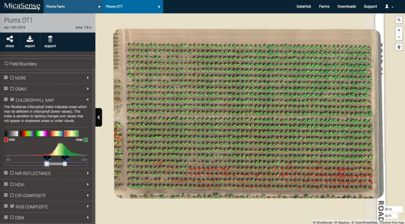
“Using multispectral data in the decision making helps myself, my dad, and the growers I’m involved with stay better informed about our fields,” Chris explains. “Case in point: looking at one of dad’s plum blocks, he has two distinctly different areas showing stress. One area, at the northwest corner of the field, has historically struggled. Here, the trees are on sandier soil. The second area is at the south end of the field, on strong soil, and is more of an anomaly. Early on in the season, some of the southern rows were yellowing from a buildup of bicarbonates in the soil.”
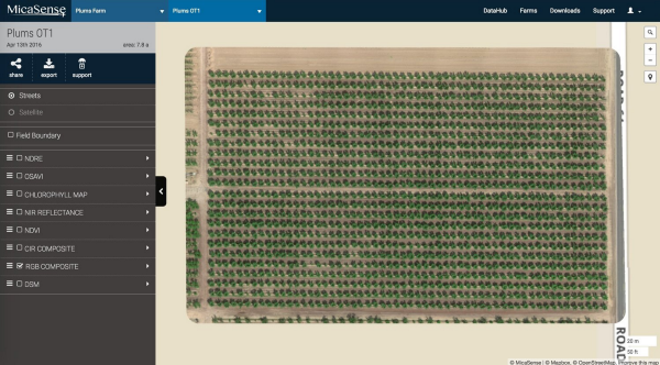
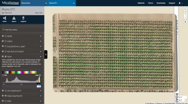
Having identified the areas of concern, Chris and his dad were able to monitor this field using advanced vegetation indices. For this field, the standard color (RGB) image did not reveal any apparent problems. The commonly used vegetation index NDVI did not provide much information either, showing relatively little variability across the orchard.


The Chlorophyll Map told a different story. This advanced map layer is generated using a combination of spectral bands available in the MicaSense series RedEdge and Parrot Sequoia professional multispectral cameras. “Using the Chlorophyll Map, we were able to see, down to the limb, which specific trees were being affected by chlorosis and to what degree. We then flew this field over the course of the summer and tracked changes.”

Chlorosis is a deficiency of chlorophyll in the leaves. Guided by the Chlorophyll Map, Chris collected tissue samples from both healthy leaves and chlorotic leaves and analyzed them for nutrient content. “Tissue samples supported our thoughts that these trees were struggling with high bicarbonates in the irrigation water, leading to a buildup in the soil.”

“At this point in the season, we were still irrigating with aquifer water,” Chris explains. “Typically, one of our first steps would be treating the soil to adjust soil pH. Fortunately, we had a decent rain year over the winter months and were about to receive our first run of surface water. Our surface water comes directly from the snow pack up in the Sierras. It’s clean and is great for flushing our soil. Instead of spending money to adjust pH, dad opted to wait for surface water.”
After flushing the soil, multispectral imagery was captured several more times with RedEdge to assess the status of the crops. The trees in the affected areas showed improvement and the symptoms that were visible on the ground were decreasing. “Our imagery justified the strategy. We could have spent a significant amount of money manually adjusting pH, which wouldn’t have helped in this scenario.” Arnold’s technology provided Chris and his dad with valuable insight into the health of their orchard, effectively saving time and money.


