When CSRS needed to pre-survey a 20,000-acre site for a future wind farm in Tunica Mississippi, they turned to veteran-owned consultancy GeoAcuity for its 20-years of specialized geospatial experience and delivery of accurate aerial surveys under tight timeframes.
Looking out your window traveling on U.S. Route 61, you can see for miles. The flat terrain surrounding Tunica Mississippi is as wide as it is vast; a stark contrast from the bustle of Memphis Tennessee, its neighbor just 20 miles North.
The local community, known best for several popular casinos located along the Mississippi River, is undergoing a period of revitalization of its public infrastructure including updates for its school system, highway improvements and a potential expansion of the Tunica Municipal Airport.
These developments are not the only source of revenue. For the last decade, Tunica County’s flat terrain has made it a hotbed for renewable energy projects and among the first to construct a utility-scale wind farm in the Southeast United States.
Lay of the Land
Architecture and engineering firm CSRS led the general project development consulting for a new wind farm covering a ~20,000-acre remote location outside of Tunica. The firm, known for its civil engineering and surveying capabilities, would leverage its environmental advisory practices to coordinate with various stakeholders and overcome challenges uncommon with wind projects in the U.S.
The proposed site of the wind farm comprised of agricultural land (rice, soybean and corn) and relatively poor soil bordered by a wetland area. CSRS would need to quickly identify wetland areas to minimize development impact on the environment and meet strenuous permitting timelines or face project delay. This data also was helpful for communications and obtaining support from landowners and government officials.
Due to the size of the project, multirotor drones would prove impractical and nearly three times more costly when considering both the coverage area and timeframe. Manned aircraft would also prove too cost-prohibitive. Thus, CSRS required a team with fixed-wing capability.
Geospatial consultancy firm GeoAcuity is known for GIS support for environmental impact statements, biological assessments and complex geospatial modeling. The veteran-owned firm brings over 21-years of specialized geospatial experience to the project and was hired to pre-survey the site of the wind farm before construction. The team was tasked with mapping all 20,000 acres within a single week and to deliver high-resolution orthomosaics, DSMs and contour maps CSRS would use in making important design and resource decisions for generator and turbine placement.
Pressed for Time
In early 2020, travel restrictions were beginning to tighten following the onset of the COVID-19 pandemic. In addition, the crops covering the proposed site were beginning to grow and would soon obscure ground visibility, which would lead to homogenous imagery that is difficult to stitch.
“We had to go quickly, and the ability to get 20,000 acres quickly was fantastic,” says Jason Knowles, Ph.D. and CEO, GeoAcuity. “We went down with two eBee X drones, both RTK enabled and just cranked it out.”

Mid-summer in Tunica is brutally hot with high temperatures and humidity that takes a toll on electronics and the field team. As a result, the crew would fly from sunrise until roughly 3:00 pm when it would get too hot for the computers to function. To capture as much ground as possible, the team relied on the power of eBee X’s 80-minute endurance batteries.
“The eBee X is a workhorse and was perfect for a job of this size. The quality of the sensors, ground control system (eMotion), extended flight times, and its high spatial accuracy using RTK corrections are indispensable to the type of geospatial work we do.”
Jason Knowles, CEO, GeoAcuity
Streamlined Workflow
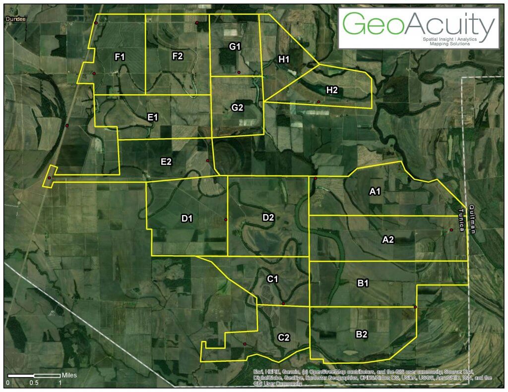
To survey such a vast area, GeoAcuity used GIS to break up the site into alphanumeric areas of interest (as shown below), pre-assigning the mission each day knowing how much they could collect. The team used this project file to track their progress.

The project collection map was also shared with local crop-dusting companies to aid in daily airspace deconfliction. From there, they’d upload the shapefile into eMotion and set all the parameters.
“Everything about eMotion is great; the fact that we can plan multiple missions is huge,” said Dr. Knowles. “I can assign missions in flight and we can have the entire days’ worth of flight plans stored in one eMotion project.”
Active RTK with GCPs was essential for this project due to the continuous, flat topography flown. Once out in the field, the team would set-up the RTK GeoBase first thing to eliminate wasted time acquiring the signal. Once established, they’d connect to the eBee, upload the mission and begin flying.
Even under the scorching heat, the eBee X drones flew their missions flawlessly, reaching their longest flight duration of ~80 minutes before returning home. Combined, the eBees flew 55 missions with zero incidents.
“It was a really streamlined operation; we got very efficient at the launching and recovery of the drones as soon as it would come down, we’d hot-swap batteries, and re-launch” says Dr. Knowles. “There was no time wasted to get the work done within the week.”
Ending each day the team would download all the imagery, backing-up flight logs and prep the eBee for the following day. Pix4Dreact was used to quick-stitch the imagery daily to ensure there were no gaps in coverage before moving on. The team would then change the symbology in their GIS project file to mark the area complete and track their progress.
Putting Data to Work
At the end of the week-long mission, the team and their eBees with the S.O.D.A. 3D camera collected roughly 48,000 georeferenced images which were processed in PIX4Dmapper. The processing time alone would take a while to complete, but the high-resolution imagery with an accuracy down to 5 cm was well worth the time for the engineering teams at CSRS.

“These large datasets are becoming more common,” says Greg Crutsinger, Ph.D. and Director of Applied Research, GeoAcuity. “With PIX4Dmatic and some of the other software options that are out there, I think we’ll solve some of these large processing needs over time; it’s more about how you best start to integrate the data.”
CSRS will use the high-resolution orthomosaic with a timestamp pre-construction for reference points used throughout the project as the site develops. The engineering team will use the Digital Surface Model (DSM) and contour maps to evaluate drainage options and locate highpoints to put transistors and electrical equipment.
For GeoAcuity, completing a project of this scale without an accurate and reliable fixed-wing UAS would have been impossible.
“We do a lot of UAS work across all of our verticals and are seeing an ever-increasing demand for UAS imagery and data. The size of the capture areas is increasing as well. The eBee X is a workhorse and was perfect for a job of this size. The quality of the sensors, ground control system (eMotion), extended flight times, and its high spatial accuracy using RTK corrections are indispensable to the type of geospatial work we do” says Dr. Knowles. “For GeoAcuity the ability to rapidly and accurately collect high-resolution data sets is a large part of what we do. From environmental consulting to disaster response, we rely on the best of the breed in UAS to help deliver the highest quality geospatial information to our clients and the eBee X certainly helps us to do that.”


