To aid in urea (nitrogen) management of rice fields in Australia, researchers at Deakin University are trialing the use of multispectral imaging. These researchers use a MicaSense series RedEdge sensor on their drone platform, giving them the ability to gather detailed information on a field with the frequency they need to monitor crop health.
For one of their trials involving a rice field, researchers completed six different flights over a three-month period, capturing calibrated data using their RedEdge sensor system. Calibration allowed the researchers to compare these different data captures, automatically compensating for the effects that varying sunlight conditions can have on the data.
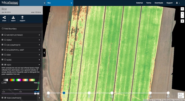
Data collected from one of the flights is displayed below. This flight was completed two weeks after a urea application was made by ground rig, just before permanent water was applied to the rice field. Both of the graphics display data captured from the same flight, the first picture is an NDVI map of the data while the second picture is an NDRE map.


It does not appear that there are any problems when the field is analyzed using the NDVI map, a vegetation index commonly used to assess plant vigor. Besides some known problem areas in the corner of the field, the NDVI map does not show any areas of concern after the urea application.
Upon further review using the NDRE map, however, it becomes apparent there was an issue, the spreader non-uniformly distributed the fertilizer.
Why did the NDVI map not show this variability? Because the nitrogen application had not yet affected plant growth and biomass (leaf area), and NDVI values correlate to the amount of biomass or leaf canopy of the plant. As a more immediate effect of the mis-application of nitrogen, chlorophyll content in the leaves dropped in the affected areas. NDRE is a much better indicator of chlorophyll levels than NDVI is, which is why the NDRE map displays the problem much more clearly.
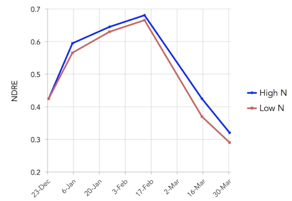
Researchers at Deakin University monitored this rice field for the remainder of the season. Leveraging the calibrated data generated by RedEdge, they tracked changes in the crop over time, monitoring the values of NDVI and NDRE for rows that experienced low or high nitrogen levels due to the non-uniform urea application at the beginning of the season.


The results show that advanced vegetation indices like NDRE (enabled by use of narrowband multispectral sensors like RedEdge) can detect the non-uniform urea application much earlier than NDVI. In this case, almost two months earlier.

At the end of the season NDVI images show the scale of variability in crop health. At this stage of growth, NDVI is a good indicator of overall biomass, and correspondingly yield of the rice crop. The difference in urea application that NDRE detected early in the season led to a significant drop in crop performance.
Advanced multispectral imaging provides valuable information that can be leveraged to undertake corrective action based on such early detection of issues. For instance, nitrogen is often applied to rice during panicle initiation, when the panicle (or head) of rice begins to form on the base of the shoot. This application supplies the rice plant’s nitrogen needs during flowering, making the quantity and timing of the application critical. Multispectral imaging can be used to aid in the decisions regarding nutrient application rates and timing, maximizing crop yield.


