Intro eBee Ag

Video eBee Ag

Data from the sky to make better decisions on the ground

Features

Efficiency is in season

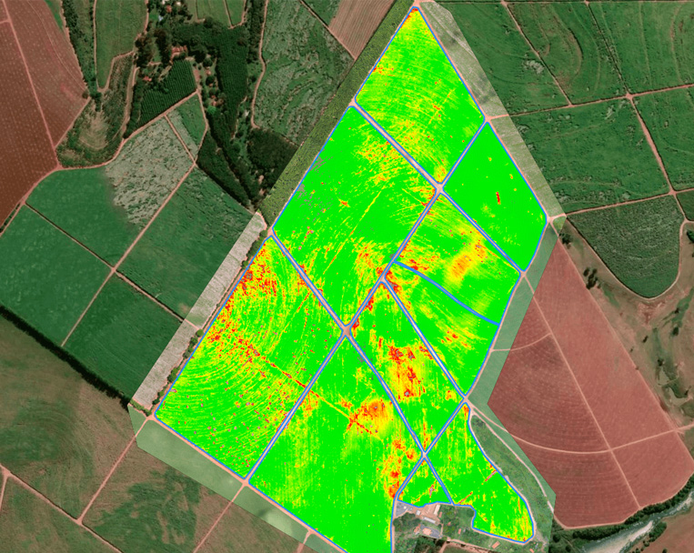
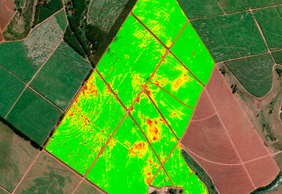
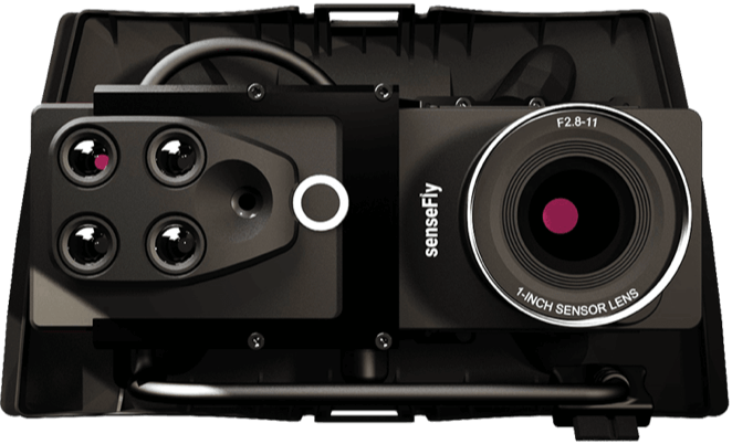
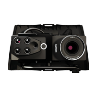
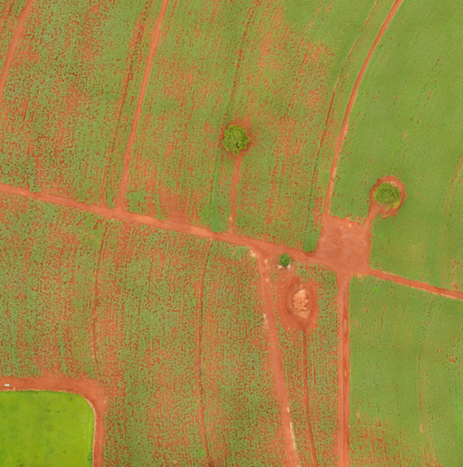
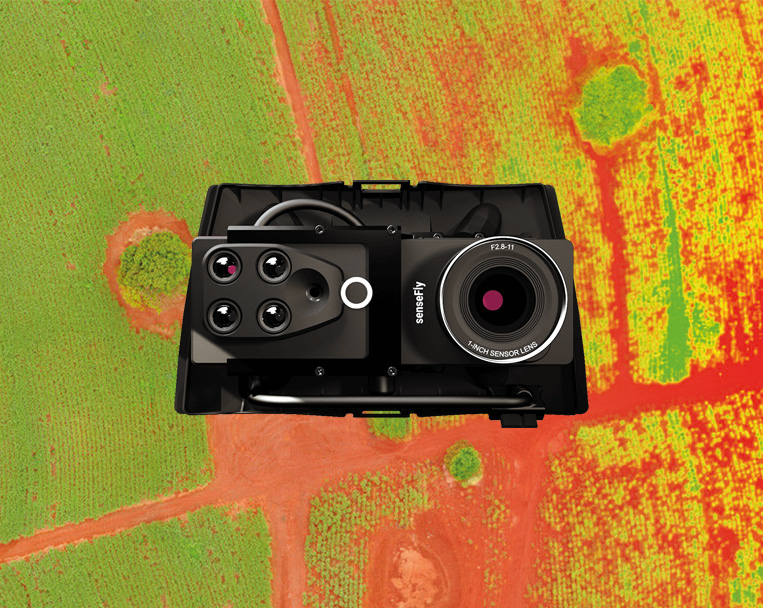
RGB + multispectral camera

The Duet M is an innovative dual-purpose RGB and 4-band multispectral camera for field mapping.


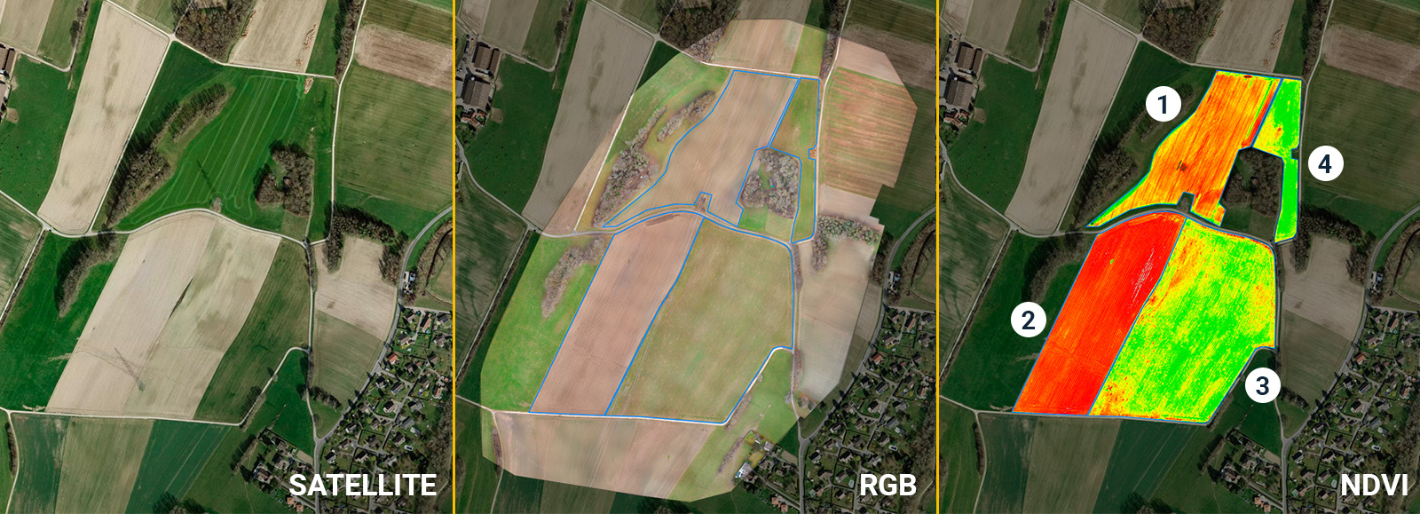
It creates geo-accurate multispectral maps – NDRE, NDVI and more – and digital surface models (DSM) with data invisible to the naked eye.

PD1-4: Product Details Card System_Text Right_with Bar Module

Background container color: Need to be able to change to any color
CTA capability: CTA button is optional… Admin needs to be able to add or remove
Eyebrow: Optional

2.5 cm / 1 in absolute accuracy

With its available RTK, the agriculture drone can achieve absolute accuracy down to 2.5 cm / 1 in with its RGB camera.

Feature weight

1.6 kg / 3.6 lbs takeoff weight

eBee Ag’s light weight allows operators to fly safely within more regulatory frameworks worldwide and increase mapping capabilities with BVLOS flights and Operations Over People.

PD1-6: Product Details Card System_Text Only Modules

Background container color: Need to be able to change to any color
CTA capability: CTA button is optional… Admin needs to be able to add or remove
Eyebrow: Optional

55 minutes flight time

Equipped with its standard battery, eBee Ag can fly up to 45 minutes. An available endurance battery increases the flight time up to 55 minutes — allowing the drone to cover 160 hectares / 395 acres in a single flight.

RTK available

eBee Ag features available Real-Time Kinematic (RTK) functionality for greater mapping precision. With RTK enabled, the agriculture drone can achieve absolute accuracy down to 2.5 cm / 1 in.

PD1-6: Product Details Card System_Text Only Modules

Background container color: Need to be able to change to any color
CTA capability: CTA button is optional… Admin needs to be able to add or remove
Eyebrow: Optional

Shock absorbent design

eBee Ag underbelly is made of reinforced polypropylene woven mesh. This shock-absorbent construction designed by our R&D team is rugged and durable.

Remote ID and C2 label

Remote ID identification system approved by the FAA is built-in eBee Ag, making it ready for upcoming drone regulations in the U.S. The fixed-wing also has a European C2 class identification label for operations in the Open Category.

Why eBee Ag

Farm-ready and easy to maintain

Integrable with agriculture software

Outputs are compatible with all major farm management information software (FMIS), which further streamline farming workflows.


PIX4Dmapper, PIX4Dfields, Agisoft, Esri Drone2Map, DroneDeploy, Trimble Ag Software, Granular, Climate FieldView, My John Deere Operations Center, AGCO Fuse, SMS, xarvio, Gamaya, Agremo, Inforow.

Applications pre, during and post-season

Applications pre, during and post-season

All-season

  • Crop development
  • Plant health (pests / diseases)
  • Nutrition
  • Well-being
  • Weeds mapping/management
  • Leak detection
  • Extreme events assessment
  • Insurance claim
  • Water management (drainage / irrigation)
  • Operation’s efficiency
  • Volumetric measurement

Pre-season

  • Land survey
  • Land distribution and measuring
  • Land topography
  • Water and soil management

Early season

  • Planting / sowing efficiency
  • Stand spacing
  • Stand counting and quality
  • Weed control

Mid-season

  • Yield prediction

Late season

  • Biomass content
  • Crop maturity
  • Soil conservation

Livestock management

  • Counting
  • Detection
  • Behavior
  • Availability of feed in extensive systems
All-season
Pre-season
Early season
Mid-season
Late season
Livestock management

All-season

  • Crop development
  • Plant health (pests / diseases)
  • Nutrition
  • Well-being
  • Weeds mapping/management
  • Leak detection
  • Extreme events assessment
  • Insurance claim
  • Water management (drainage / irrigation)
  • Operation’s efficiency
  • Volumetric measurement

Pre-season

  • Land survey
  • Land distribution and measuring
  • Land topography
  • Water and soil management

Early season

  • Planting / sowing efficiency
  • Stand spacing
  • Stand counting and quality
  • Weed control

Mid-season

  • Yield prediction

Late season

  • Biomass content
  • Crop maturity
  • Soil conservation

Livestock management

  • Counting
  • Detection
  • Behavior
  • Availability of feed in extensive systems

Easy to use

Easy to use

Fields vary in size and shape, but eBee Ag and eMotion flight management software make crop scouting and monitoring smart.

Hand-launched

Suited for repeated crop mapping missions, the drone can restart a mission as soon as it lands.

3 minutes deploy

Assemble and get your drone ready to fly very quickly. Can be operated by one person.

Automated data

Automatically collects aerial data and lands at the designated landing point.

Fully portable eBee Ag

Fully portable

All you need to map your field with included drone backpack.

Laptop pocket and rain cover.

4.6 kg / 10 lbs empty.

10 kg / 22 lbs fully loaded.

PD1-3: Product Details Card System_Text Left_No bar_Module

Background container color: Need to be able to change to any color CTA capability: CTA button is optional… Admin needs to be able to add or remove Eyebrow: Optional

Affordable drone

eBee Ag is an affordable agricultural drone for cost-conscious farmers, agronomists and service providers.


With this fixed-wing ag drone, producers now have access to more accurate field and crop assessments, soil analyses and data that allow for smarter scouting and decision-making.

Reliable

Reliable

eBee Ag delivers accurate and timely field health insights for making informed decisions and achieving greater profit potential.


The U.S. Federal Aviation Administration (FAA) drone registration data from 2016 to 2021 confirms that eBee is the most used fixed-wing drone in the U.S.

500,000 +

eBee flight hours

1,000,000 +

eBee successful flights

Preflight checks

Automated quick self-diagnosis before every flight

12 years

Industry experience

PD1-3: Product Details Card System_Text Left_No bar_Module

Background container color: Need to be able to change to any color CTA capability: CTA button is optional… Admin needs to be able to add or remove Eyebrow: Optional

In the field

Operate in all fields

eBee Ag is designed for maximum uptime and offers incredible reliability in the field.


Our R&D team has created a robust underbody made from reinforced polypropylene woven mesh that protects the drone from damage when belly landing in harsh terrain.

PD1-5: Product Details Card System_Text Right_No Bar Module

Background container color: Need to be able to change to any color
CTA capability: CTA button is optional… Admin needs to be able to add or remove
Eyebrow: Optional

In the field

Less downtime and maintenance costs

eBee Ag’s modular design lets you easily swap out parts as needed and continue your mission in the field.


Maintenance is also very simple and fast, thanks to our global support network, where you can get your drone repaired locally.

Safety eBee Ag

Safe drone

Safe to fly around people – demonstrated with impact tests.

Free from rear-facing motor and hard plastic parts.

Safety features integrated into flight management software.

Expanded capabilities

Expanded capabilities

eBee Ag lightweight design reduces ground impact effects and makes it suitable for advanced operations. This allows farmers and growers to expand their mapping capabilities.

Regulatory advantages

Operators benefit from eBee Ag lightweight – 1.6 kg / 3.6 lbs – to fly within more regulatory frameworks worldwide.

Increased capabilities

This advanced and scalable drone for agriculture is perfect to tackle the high demands of commercial agriculture projects and big farms, in all kinds of environments.

Customer Reviews

eBee Ag customer reviews

What our customers say

“There are a lot of $5,000 UAVs available, but they don’t fly themselves so they’re basically fancy remote controlled helicopters. With the senseFly eBee Ag you get a complete solution—take a couple minutes to plan a mission, launch it by hand (no catapults), and the eBee does the rest. It flies, takes images, figures out the wind and lands right where you want it to. There’s nothing more portable, powerful and easy to use.”

“The eBee Ag is our main tool for precision agriculture. We have found it a remarkable tool for identifying issues within crops before problems become too severe. When the results from the eBee Ag are coupled with targeted soil testing, exceptionally accurate prescriptions can be made. The eBee’s simplicity and quick results are what have made it so valuable to us.”

“Thanks to the eBee’s multispectral maps we have managed to reduce our operational and logistical costs by 30%, through being able to define different sugarcane harvest zones based on the crop’s quality in different regions. That work resulted in an increase of 15% in the value of the product we sold to our customers.”

Camera

Multispectral + RGB

eBee Ag Camera

Duet M

The Duet M is a dual-purpose RGB and 4-band multispectral camera for field mapping. By combining both types of imagery, users can quickly spot troublesome areas in high-resolution RGB and gain critical NDVI data invisible to the naked eye — all in one flight.

The data captured with this drone camera is transformed into geo-accurate multispectral maps, digital surface models (DSM) and vegetation indices such as NDVI, NDRE, LCI, and more.

Explore datasets

Application example

Application example

Area 1

This image compares the satellite map vs. the RGB and NDVI data collected with the drone. The NDVI dataset showcases the crop emergence stage, percentage and planting orientation.

Area 2

Zone ready to be planted. It shows the presence of weeds, and farmers can choose to apply a pre-plant herbicide application for control if necessary to specific infested spots.

Area 3

Showcases the post-emergence vigor of the crop, such as the quality of the stand, planting failures, stand health, and allows farmers to see both problematic and healthy areas.

Area 4

Allows the identification of any specific problem spots or regions in the field.

Accessories

Hardware and software included

eMotion

eMotion flight planning software

Learn More

Plan your mission

Planning your project is as easy as selecting the flight block type and the area you want to map, and the software generates the eBee Ag flight plan. You can choose your mission settings, like GSD and overlap, or let eMotion automatically optimize them.

Monitor and adjust your flight

From automating single flights to flying multiple eBees simultaneously, eMotion’s 3D environment helps you control the drone’s trajectory. You can easily activate the safety features in a single click or adjust the flight path and landing spot during flight.

Gather data with geotagged images

eMotion includes all the functionality you need to collect the geospatial data you require, such as automatically geotagged images, custom background maps, safety features, live air traffic, RTK, and weather forecast.

Export your mission for post-processing

The drone managing software connects wirelessly to your UAS, industry cloud solutions, base stations, and airspace data. Furthermore, eMotion prepares the images for post-processing software, reducing third-party software compatibility issues.

Extensions

Extensions

Endurance extension

Fly up to 55 minutes in a single flight (endurance battery required).

Endurance battery

Available endurance batteries allow for flight times of up to 55 minutes.

RTK activation

Achieve absolute accuracy of down to 2.5 cm / 1 in with available RTK.

Extended warranty

Fly with confidence with this one-year warranty extension.

Hard case

Provide extra protection for your eBee Ag in harsh environments.

Certified operator

Get the most from your agriculture drone with this training.

GeoBase by Septentrio Altus NR3

Enable high-accuracy workflow with this plug-and-play GNSS.

Ping USB

Increase your airspace awareness by viewing live air traffic data directly within eMotion.

Radio tracker

Safeguard against unexpected aircraft signal loss while flying in high winds, mountainous areas or very large areas out of line of sight.

Spare and maintenance kits

Wings, pitot tube, vertical surfaces and propellers.

Remote control

Operate your eBee Ag drone manually.

Support and training eBee Ag

Local support

Should you require support in the field at any time, our global network of support service centers stands by to help.

We are recognized throughout the industry for excellence in customer service.

Our drone solutions include lifetime hardware, payload and eMotion support, plus free software and firmware updates.

Get support

Training programs

The Certified Operator course will allow you to get the most from your fixed-wing drone and increase your operations’ ROI. 

Not sure if the course is right for you? Try the first four lessons for free!

In addition, we offer personalized professional training packages online and in person. Contact us to book a custom session with a distributor or us.

Start Certified Operator course

Use cases eBee Ag

eBee Ag use cases

Webinar

5 tips for maximizing crop management with drones

Get ahead of troublesome weeds and prioritize your operations. Webinar with Trimble.

Watch webinar

Case study

Mapping 8,000 ha / 19,768 ac in 3 days

Multi-drone flights with eBee Ag and X for arable land surveying and estimates.

Read case study

Blog

Drones in agriculture: benefits and things to consider

Benefits of drone technology in agriculture and key considerations before investing.

Explore blog

Newsletter sign up

Sign up to receive updates directly to your inbox.