

How are sUAS used in national defense?
Tactical military or humanitarian land operations heavily depend on the terrain, Arnold systems collect and process near real-time accurate data that help the commandment to define the environment.
Tactical mapping – Warfighters and frontline defenses use rapidly deployable UAVs to map terrain and areas of interest. This near real-time situational awareness provides ground forces with a tactical advantage for planning mission operations while enhancing safety.
Intelligence – Mission-directed swappable sensors such as RGB, 3D, multispectral and thermal allow sUAS to provide detailed intelligence for analysis and decision making. Unclassified intelligence can be shared and integrated with situational awareness tools such as ATAK.
Reconnaissance – Gather real-time intelligence about the local terrain, friendly unit actions, equipment recognition and possible enemy threats and can be used to identify environmental changes over time.
How are sUAS used for intelligence preparation of the battlefield?
Accurate geospatial information is the foundational component for intelligence preparation on the Battlefield.
Area obstacles – Aerial 3D maps visualize terrain adding realism to mission planning and rehearsal activities for urban missions.
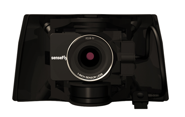
Choke points – Operators can use 3D imagery to characterize choke points for traffic and mission operations using real dimensions. For example, cameras such as the S.O.D.A. provide an RGB resolution of 5,472 x 3,648 px for detailed, vivid orthomosaics and ultra-accurate 3D digital surface models.
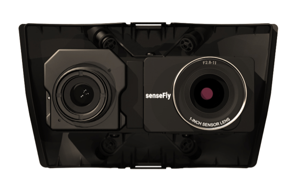
Concealment – Thermal camera-generated 2D maps help soldiers see areas of interest not visible in RGB imagery. The eBee series Duet T thermal mapping camera includes a high-resolution thermal infrared (640 x 512 px) camera and a S.O.D.A. RGB camera with a built-in Camera Position Synchronisation feature for seamless image overlays.
Cross-country mobility – As planned courses often change, sUAV operations need the flexibility to modify missions on-the-fly to provide additional input as required and complete the mission.
Fields of fire – The degree of detail required in analyzing the battlespace environment varies depending on the mission; and for this reason, the operator can adapt eBee sUAV accuracies to the mission.
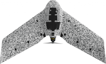
Mobility corridors – In complex environments eBee sUAS help operators to open mobility corridors quickly. For example, eBee TAC enables operators to map up to 18.7 km / 11.6 mi, approx. 3X longer corridors than a typical quadcopter’s coverage of 9 km / 5.6 mi per battery by comparison.
Road networks – Rapidly shifting environments requires a highly accurate mobile solution to provide current intel on roadways and threats. The eBee TAC can cover up to 500 ha / 1,235 ac mission coverage while flying at 120 m / 400 ft to deliver insights on transportation and infrastructure for planning, decisions and safe transport.
How are sUAS used for intelligence preparation for non-military?
Humanitarian assistance and disaster relief – Accurate 3D mapping enables improved logistics, damage assessments, disaster risk reduction, and a quick overview of the condition of a community.
Counterdrug operations – Thermal cameras deliver day and night mapping capabilities for counter-drug agents conducting frequent mapping of suspicious areas.
Peacekeeping operations – sUAVs can identify areas of population densities and options for relocation should conflict arise.
Shows of force – eBee sUAS provide simultaneous multi-drone flight functionality that defending forces can use to show their presence to enemies in the region and reinforce boundaries.
Evacuation operation – When disaster strikes, detailed 2D maps help emergency responders define safe corridors for entry and rescue operations.
Security and patrol – Detailed 3D models and thermal maps of buildings and terrain allow security personnel and border agents to monitor boundaries, assess threats and protect critical assets.
Incident response – Following an incident, aerial intelligence allows ground forces to assess, document or reconstruct the scene with high accuracy and proceed with confidence for recovery and extraction.
What are the benefits of sUAS to soldiers?
Improved situational awareness – sUAVs provide battalion-and-below ground-maneuver capabilities guided by on-demand aerial intelligence. Small unit commanders can use real-time high-resolution maps for responsive tactical reconnaissance, surveillance and target acquisition.
Enhanced force protection – Unclassified aerial maps can be integrated with situation awareness tools such as ATAK for seamless communication and coordination of forces in the field.
Secure navigational routes – Tactical mapping provides commanders advance visibility for planning safe transport routes for mobilized troops. Tactical mapping on-demand (TMOD) provides teams with a higher reactivity time and safety because they don’t need to wait for the availability of planes, helicopters or satellites and pilots and airmen can focus on value-added missions instead.
Fast procurement – Systems added to the Blue UAS list, such as eBee TAC, do not require a DoD exception policy to procure or operate as they have undergone a cyber-security evaluation, a policy compliance check, and were issued the necessary administrative documentation. Federal government partners can also leverage this effort for their programmatic needs without duplicating efforts.
What types of sUAS data outputs are available?
3D models – A three-dimensional texture map (X, Y, Z) that displays the site’s surfaces, walls and edges with high precision. High-resolution 3D models are used to generate digital twins of terrain, cities and critical infrastructure. This reconstructed intelligence helps with operations preparation, planning and running VR simulations before sending orders to the field.
Orthomosaic maps – A geospatially accurate and detailed 2D representation of a site by combining a large number of nadir drone images. These maps can be rapidly processed in the field as unclassified intelligence that can be shared with units in the field.
Terrain and Digital Surface Models (DSMs) – DSM maps take 2.5D information to give an accurate elevation representation of the field of operations. Aerial photo data mapped onto a terrain model base is helpful for conducting surveys and developing tactical strategies.
Thermal maps – Thermal photogrammetry allows for target detection through structures and environmental obstructions such as smog and smoke for surveillance or tracking.
What software do you need?
- eMotion software is a leading drone software solution for flight planning, geotagging and photo stitching. From here the imagery can be exported for further processing in Pix4D and other software.
- Military forces can also integrate further with ATAK for situational awareness, moving maps and the ability to share unclassified data quickly, accurately and securely – while mitigating risk.
